Zum Inhalt springen

Datei:Kashmir map.jpg

Aus MOOCsWiki Staging
Originaldatei (974 × 1.120 Pixel, Dateigröße: 807 KB, MIME-Typ: image/jpeg)

Diese Datei stammt aus Wikimedia Commons und kann von anderen Projekten verwendet werden. Die Beschreibung von deren Dateibeschreibungsseite wird unten angezeigt.

Beschreibung

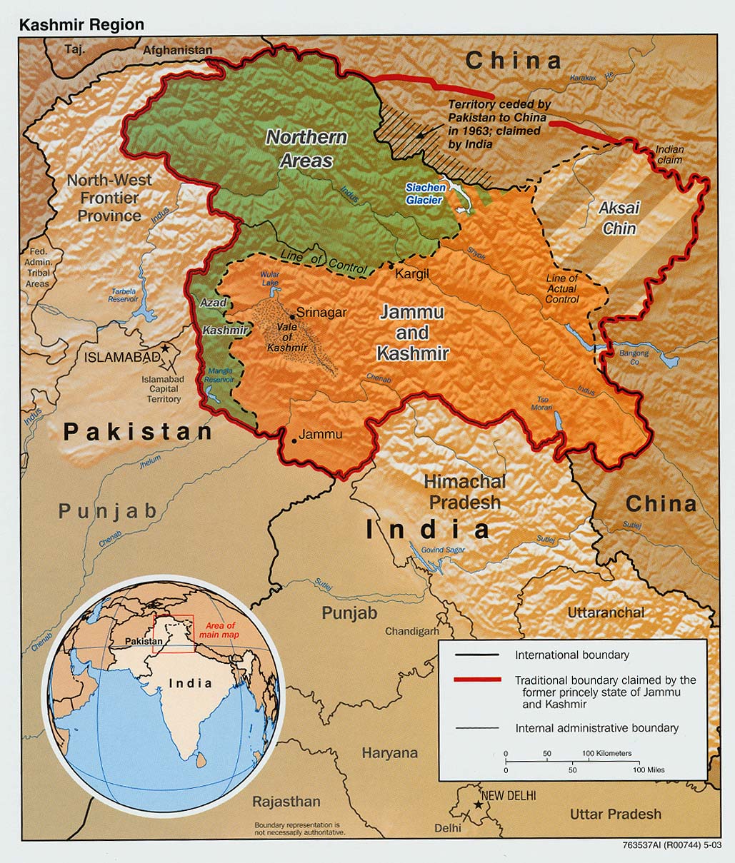
Deutsch: Übersicht über den gegenwärtigen Status Kaschmirs: Das auf der Karte grün eingefärbte Gebiet ist unter pakistanischer Kontrolle, der orange-braun eingefärbte iat als Bundesstaat Jammu und Kashmir unter indischer während Aksai Chin chinesisch besetzt ist.
English: The Disputed Territory : Shown in green is Kashmiri region under Pakistani control. The orange-brown region represents Indian-controlled Jammu and Kashmir while the Aksai Chin is under Chinese control.
Español: Mapa de la región de Cachemira. En verde, el territorio ocupado por Pakistán; en naranja, el ocupado por la India
Beschreibung

Original text from CIA World Factbook: "The Disputed Territory : Shown in green is Kashmiri region under Pakistani control. The dark-brown region represents Indian-controlled Jammu and Kashmir while the Aksai Chin is under Chinese occupation."

Library of Congress, Geography and Map Division, Washington, D.C. 20540-4650 USA. Info from its archive page [1] for this map:

Kashmir region.

United States. Central Intelligence Agency.

CREATED/PUBLISHED [Washington : Central Intelligence Agency, 2003]

NOTES "763537AI (R00744) 5-03."

Relief shown by shading.

Shows boundaries and disputed areas.

Includes location map.

Scale [ca. 1:510,000].

SUBJECTS

Jammu and Kashmir (India)--Maps
Jammu and Kashmir (India)--Boundaries--Maps.
India--Jammu and Kashmir.

MEDIUM 1 map : col. ; 20 x 17 cm.

CALL NUMBER G7653.J3 2003 .U51

REPOSITORY Library of Congress Geography and Map Division Washington, D.C. 20540-4650 USA

DIGITAL ID

g7653j ct001059 http://hdl.loc.gov/loc.gmd/g7653j.ct001059
Datum
Quelle

Map is archived here: http://hdl.loc.gov/loc.gmd/g7653j.ct001059 and

http://www.lib.utexas.edu/maps/middle_east_and_asia/kashmir_disputed_2003.jpg
Urheber Central Intelligence Agency
Genehmigung
(Weiternutzung dieser Datei)
Public domain
Dieses Werk ist gemeinfrei, weil es Bildmaterial aus dem CIA World Factbook darstellt, das ursprünglich vom Zentralen Nachrichtendienst der Vereinigten Staaten veröffentlicht wurde.

Bahasa Indonesia ∙ čeština ∙ Deutsch ∙ eesti ∙ English ∙ español ∙ Esperanto ∙ français ∙ galego ∙ hrvatski ∙ italiano ∙ Nederlands ∙ norsk nynorsk ∙ polski ∙ português ∙ sicilianu ∙ slovenščina ∙ suomi ∙ Türkçe ∙ Zazaki ∙ беларуская (тарашкевіца) ∙ македонски ∙ русский ∙ српски / srpski ∙ українська ∙ ქართული ∙ বাংলা ∙ தமிழ் ∙ മലയാളം ∙ 한국어 ∙ 日本語 ∙ 中文 ∙ 中文(简体) ∙ 中文(繁體) ∙ العربية ∙ +/−

Andere Versionen العربيَّة

Kurzbeschreibungen

Ergänze eine einzeilige Erklärung, was diese Datei darstellt.

In dieser Datei abgebildete Objekte

Motiv

826.329 Byte

1.120 Pixel

974 Pixel

image/jpeg

966a4464aebfe4261df673ee19d213adf2dc63e6

Dateiversionen

Klicke auf einen Zeitpunkt, um diese Version zu laden.

Version vomVorschaubildMaßeBenutzerKommentar
aktuell10:34, 6. Mär. 2016Vorschaubild der Version vom 10:34, 6. Mär. 2016974 × 1.120 (807 KB)wikimediacommons>DennissReverted to version as of 23:18, 6 June 2010 (UTC)